
Advanced Certificate in Earth Observation Data Processing Methods
This certificate equips learners with advanced skills in processing and analyzing Earth observation data for professional applications.
Advanced Certificate in Earth Observation Data Processing Methods
Programme Overview
The Advanced Certificate in Earth Observation Data Processing Methods is designed for professionals and advanced students in remote sensing, environmental science, and related fields who seek to enhance their capabilities in processing and analyzing Earth observation data. This program equips participants with advanced techniques and tools for interpreting data from various sources such as satellite imagery, airborne sensors, and ground-based measurements, focusing on applications in environmental monitoring, climate change research, natural resource management, and disaster response.
Over the course of the program, learners will develop a deep understanding of data processing methods, including image classification, change detection, time series analysis, and machine learning applications. They will gain hands-on experience using state-of-the-art software and programming languages such as Python, R, and GIS tools, and learn to apply these skills to real-world datasets. The program also emphasizes the integration of spatial data with other types of information to support informed decision-making and policy development.
Upon completion, participants will be well-prepared to lead projects in data analysis, contribute to interdisciplinary research teams, and apply their skills in various industries, including environmental consulting, government agencies, non-profit organizations, and private sector companies. The program's focus on practical application ensures that graduates are ready to implement their knowledge in real-world contexts, potentially leading to advancements in environmental conservation, resource management, and sustainable development initiatives.
What You'll Learn
Embark on a journey to harness the power of Earth observation data with our Advanced Certificate in Earth Observation Data Processing Methods. This comprehensive program equips you with cutting-edge skills in satellite imaging, remote sensing, and geospatial analysis, designed to meet the demands of today’s data-driven world. Key topics include image acquisition, data preprocessing, classification techniques, and advanced analytical methods, all underpinned by hands-on practice with state-of-the-art software and tools.
Upon completion, you will be well-prepared to process and interpret complex Earth observation data, contributing to a wide range of applications from environmental monitoring and disaster response to urban planning and agricultural management. Graduates can apply their expertise in both public and private sectors, working with government agencies, international organizations, and private enterprises. Career opportunities span roles such as data analyst, environmental consultant, and remote sensing specialist, opening doors to a dynamic and growing field. Join us to transform data into actionable insights that drive sustainable solutions and informed decision-making.
Programme Highlights
Industry-Aligned Curriculum
Developed with industry leaders for job-ready skills valued by employers worldwide.
Globally Recognised Certificate
Recognised by employers across 180+ countries as a mark of professional excellence.
Flexible Online Learning
Study at your own pace with lifetime access to all course materials and updates.
Instant Access
Start learning immediately — no application process or waiting period required.
Constantly Updated Content
Stay ahead with the latest industry trends, best practices, and emerging insights.
Career Advancement
87% of graduates report measurable career progression within 6 months of completion.
Topics Covered
- 1. Remote Sensing Fundamentals: Learners will study the basic principles of remote sensing, including electromagnetic radiation and sensors. This module will provide foundational knowledge in interpreting satellite and aerial imagery.
- 2. Geospatial Data Analysis: Students will explore the analysis and management of geospatial data, focusing on spatial statistics and data visualization techniques to gain practical skills in handling and interpreting geospatial information.
- 3. Image Processing Techniques: This module covers various image processing methods, including radiometric and geometric corrections, and learners will gain skills in enhancing and preparing remote sensing data for analysis.
- 4. Change Detection: Students will learn methodologies for detecting changes in Earth's surface over time using multi-temporal remote sensing data, essential for environmental monitoring and change analysis.
- 5. Machine Learning for Remote Sensing: This module introduces machine learning techniques for analyzing remote sensing data, focusing on classification and regression models to predict and map land use and cover changes.
- 6. Time Series Analysis of Remote Sensing Data: Learners will study advanced techniques for analyzing time series datasets to understand temporal patterns and trends in environmental and urban dynamics.
- 7. GIS Integration with Earth Observation Data: This module focuses on integrating Earth observation data with Geographic Information Systems (GIS) for comprehensive environmental and spatial analysis.
- 8. Big Data Processing for Earth Observation: Students will learn to process and analyze large volumes of Earth observation data using big data technologies, essential for handling modern remote sensing datasets.
- 9. Remote Sensing for Natural Disaster Management: This module explores the application of remote sensing in disaster risk assessment, early warning, and post-disaster management, providing skills in utilizing remote sensing for emergency response.
- 10. Case Studies in Earth Observation Data Processing: In this concluding module, learners will apply the knowledge and skills gained throughout the programme to real-world case studies, enhancing their ability to solve complex Earth observation problems.
What You Get When You Enroll
Secure checkout • Instant access • Certificate included
Key Facts
Aimed at professionals and students
No formal prerequisites required
Gain practical data processing skills
Understand Earth observation techniques
Analyze remote sensing data effectively
Develop Python scripting abilities
Prepare for advanced certifications
Ready to get started?
Join thousands of professionals who already took the next step. Enroll now and get instant access.
Enroll Now — $149Why This Course
Specialized Skill Enhancement: The Advanced Certificate in Earth Observation Data Processing Methods equips professionals with cutting-edge skills in handling and processing Earth observation data. This includes expertise in remote sensing technologies, geospatial analysis, and data interpretation, which are crucial for environmental monitoring, natural resource management, and disaster response.
Career Advancement Opportunities: Gaining this certification can significantly enhance career prospects by making professionals more competitive in the job market. It opens doors to roles such as Earth observation data analyst, GIS specialist, and environmental consultancy, where demand for skilled professionals in data processing is high.
Interdisciplinary Collaboration: The program fosters an understanding of how Earth observation data can be applied across various sectors like agriculture, urban planning, and climate change research. This broadens professional networks and collaborations, leading to more innovative solutions and project opportunities.
Your Path to Certification
Trusted by Professionals Worldwide
Course Brochure
Download our comprehensive course brochure with all details
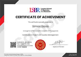
Sample Certificate
Preview the certificate you'll receive upon successful completion of this program.
Get Free Course Info
Enter your details and we'll send you a comprehensive course information pack straight to your inbox.
Employer Sponsored Training
Let your employer invest in your professional development. Request a corporate invoice and get your training funded.
Request Corporate InvoiceWhat People Say About Us
Hear from our students about their experience with the Advanced Certificate in Earth Observation Data Processing Methods at LSBRX - Executive Education.
Sophie Brown
United Kingdom"The course content is incredibly comprehensive, covering advanced techniques in Earth observation data processing that directly translate into practical skills for analyzing satellite imagery. Gaining proficiency in these methods has significantly enhanced my ability to contribute to environmental monitoring projects."
Siti Abdullah
Malaysia"This course has significantly enhanced my ability to process and analyze Earth observation data, making me more competitive in the job market. The practical applications I've learned have already helped me tackle real-world problems in my current role, leading to faster project completion and better outcomes."
Charlotte Williams
United Kingdom"The course is meticulously organized, providing a seamless progression from foundational concepts to advanced techniques in earth observation data processing, which has significantly enhanced my ability to apply these methods in real-world scenarios."